Searching for "mobile devices"
Enabling Bring Your Own Device
white paper by the Cisco
To help improve understanding of BYOD and its impacts on modern network environments, this white paper will further explore the many differences that exist between corporate and educational approaches to the technology.
In the education space, dealing with non-standard, user-managed devices has been and still remains the norm. Unfortunately, the variety of devices means a multitude of operating systems and software are encountered, with many “standards” being defined. As a result there is little consistency in the device type or the software being installed. Since the device is owned by the student and is a personal resource, it is often difficult or impossible to enforce a policy that prevents users from installing software. In addition, due to the nature of learning as opposed to a corporate environment, it is also difficult to put a restriction on certain classes of software since all may provide a worthwhile educational purpose.
providing a solution that unifies management and deployment polices across both wired and wireless devices is very desirable.
The Internet of Everything (IoE) has spurred a revolution in mobility. Collaboration anywhere, anytime and with any device is quickly becoming the rule instead of the exception. As a result it is now common for students to bring mobile devices such as smartphones, tablets and e-readers into the academic environment to support their educational endeavors.
The infrastructure supporting BYOD no longer has the sole purpose of providing a wireless radio signal within a given area. The focus is now about providing the appropriate bandwidth and quality to accommodate the ever-growing number of devices and ensure that an application provides a good end-user experience. In a sense, applications are now the major driving force behind the continuing evolution of BYOD. For example, a teacher accessing video in the classroom for educational purposes during class hours should have greater priority than a student in the same area accessing a gaming site for recreation.
A state-of-the-art BYOD infrastructure should now be capable of providing more than just generic, general-purpose wireless connectivity. In the classroom environment, the notion of “differentiated access” often resonates with faculty and staff. Once this has been determined, a policy can be applied to the user and their activity on the network.
Granular security can also be intelligently delivered.
Quality of Service (QoS) rate limiting has been available for some time, but now there are newer QoS techniques available.
Location-based services can provide their first interaction with the university. By delivering campus maps and directional information, location-enabled services can enhance the experience of these visitors and provide a positive image to them as well. As a visitor enters a particular building location, information could automatically be provided. In the case of a visiting student, information about the history of a building, departments contained within the building, or other resources could be presented to enhance a guided tour, or provide the perspective student the ability to have a self-directed tour of the campus facilities.
802.11ac Technology (https://en.wikipedia.org/wiki/IEEE_802.11ac)
Software Defined Networking (https://en.wikipedia.org/wiki/Software-defined_networking)
5 Essential Insights About Mobile Learning
http://ww2.kqed.org/mindshift/2014/07/15/5-essential-insights-about-mobile-learning/
1. Set goals and expectations for teaching and learning with mobile devices before worrying about the device itself.
St. Vrain Valley School District in Colorado,
Mooresville Graded School District
Consolidated High School District 230
2. Develop a strong community of support for the initiative early and keep up transparent communication with parents and community members throughout the process.
Forsyth County Schools in Georgia.
3. Think about equity, but don’t let it stop forward motion.
includes both urban and rural areas,
4. Evaluate the effectiveness of a mobile learning initiative based on the goals set at the beginning of the rollout.
5. Some of the biggest lessons learned include giving up control and trusting students.
included students in the discussions
STAY NIMBLE
While these mobile learning pioneers have seen some of the pitfalls and can help districts new to the game avoid the same stumbles, this space is changing quickly and every community’s needs will be different.
“It’s no longer just something you implement; it’s evolving and it’s unique in each location,” Bjerede said. “If you try to be cookie cutter about it you won’t meet the needs of every kid in every classroom.”
The technology will change, students will surprise their teachers and the best advice to district leaders is to stay open to all the possibilities and allow students to take control of the tremendous learning opportunity that having a device at all times could offer them.
=====================================
My note: Kathrina Schwartz offers an opinion, which reflects the second wave (withdrawl) in the 3 steps of innovation
The Struggles and Realities of Student-Driven Learning and BYOD
http://ww2.kqed.org/mindshift/2014/07/07/the-struggles-and-realities-of-student-driven-learning-and-byod/
A 2013 Pew study revealed that only 35 percent of teachers at the lowest income schools allow their students to look up information on their mobile devices, as compared to 52 percent of teachers at wealthier schools.
Many advocates of using mobile technologies say the often cited issues of student distraction are just excuses not to try something new.
“The way you discourage it is engage them in the activity so they don’t even think of sending a text. You’ve got to jump in and play their game or you’re going to lose them.”
Angela Crawford has heard all the arguments of BYOD evangelists, but doesn’t see how they match the reality of her classroom. “BYOD is very problematic in many schools, mine included, because we have a prominent engagement problem,” Crawford said.
Tactics to improve engagement like making work relevant to her students’ lives or letting them use their phones in class to look up information, haven’t worked for Crawford, although she’s tried.
When she first started, Crawford was enthusiastic about jumping into collaborative, project-based learning. “I thought my colleagues were monsters because of how they were teaching,” she said of a school where she previously worked and where teachers lectured all the time. She tried to teach students through projects, but found it was a disaster. To her students’ parents, her efforts to make the classroom “student-centered” looked like she wasn’t teaching. “There is a different perception of what a teacher should be in different cultures,” Crawford said. “And in the African-American community in the South the teacher is supposed to do direct instruction.”
“What works best for each student is really the heart of student-centered learning,” Crawford said. “Sometimes what the student needs best is direct instruction. They need that authoritative, in-control figure who is directing their learning and will get them where they need to go.” Many of Crawford’s students come from homes run by single mothers who rule with an iron hand. She tries to replicate that attitude and presence. “They respond to that; they like it,” Crawford said. “It’s comforting to them.”
Still, Crawford will not be experimenting with a bring-your-own-device program. “My problem with education innovation is we tend to want to take a new technology or a new idea and go forth with it as if it’s the silver bullet,” Crawford said. “What happens is that teachers who teach in my type of environment realize this would be a disaster in my classroom.”
Crawford is skeptical that kids in higher income areas aren’t misusing technology too. Her children attend school in a more affluent district and they tell her that kids are constantly messing around on their devices. They just switch screens when a teacher comes by. They get away with it because their teachers trust them to do their work.
“I think kids in middle class or upper middle class schools are equally distracted as low-income students,” said Bob Lenz, director of innovation at Envision Schools, a small charter network that’s part of the deeper learning movement. “It’s just that because of the privilege of their background the content and the skills that they need to gain in school — they’re coming with a lot of those skills already– so it’s not as urgently needed.”
Based on the literature regarding games, gaming, gamification, game-based learning, and serious games, several clear trends emerge:
- Gaming and gamification in the sense of game-based learning is about using games and game-like tactics in the education process, for greater engagement and better learning outcomes. However, this is only the first level of such initiative. The second and higher level is about involving students in the game-building and gamification of the learning process (as per Vygotsky’s Zone of…) thus achieving student-centered and experiential learning.
- When hosting games and gaming in any library, “in-person” or electronic/online games are welcome but not sufficient to fulfill their promise, especially in an academic library. Per (1), an academic library has the responsibility to involve students and guide them in learning how to engage in the building process required in true game-based learning.
- Game-based learning, gaming and gamification in particular, in educational (academic library) settings must consider mobile devices and the BYOD movement in particular as intrinsic parts of the entire process. Approaching the initiative primarily by acquiring online “in-person” games, or game consoles has the same limited educational potential as only hosting games, rather than elevating the students to full guided engagement with game-based learning. If public relations and raised profile are the main goals for the academic library, such an approach is justified. If the academic library seeks to maximize the value of game-based learning, then the library must consider: a. gaming consoles, b. mobile devices as part of a BYOD initiative and c. cloud-based / social games, such as MineCraft, SimCity etc.
- Design for game-based learning, gaming and gamification in educational (academic library) settings must include multiple forms of assessment and reward, e.g. badges, leaderboards and/or certificates as an intrinsic part of the entire process. Merely hosting games in the academic library cannot guarantee true game-based learning. The academic library, as the forefront of a game-based learning initiative on campus, must work with faculty on understanding and fine tuning badges and similar new forms of assessment and reward, as they effectively implement large scale game-based learning, focused on the students’ learning gains.
Recommendations for LRS
- In regard to LRS, the gaming and gamification process must be organized and led by faculty, including housing and distributing the hardware, software and applications, when needed.
- The attached paper and the respective conclusions summarized in four points demand educational and experiential background, which is above the limits of the LRS staff. In addition, the LRS staff has clearly admitted that the pedagogical value of gaming and gamification is beyond their interest. This recommendation is not contradicting to the fact and opportunity for LRS staff to participate in the process and contribute to the process; it just negates the possibility of staff mandating and leading the process, since it will keep the gaming and gamification process on a very rudimentary level.
- The process must be further led by faculty with a terminal degree in education (Ph.D.) and experience in the educational field, since, as proved by the attached paper and 4 point conclusion, the goal is not a public-library type of hosting activities, but rather involving students in a pedagogically-sound creative process, with the respective opportunity for assessment and future collaboration with instructors across campus. This recommendation is not contradicting the fact and opportunity for LRS library faculty to participate actively in the process and contribute to the process. It just safeguards from restricting the process to the realm of “public-library” type of hosting activities, but failing to elevate them to the needs of an academic campus and connecting with instructors across campus.
- This conclusions adhere to and are derived from the document recommended by the LRS dean, discussed and accepted by LRS faculty in 2013 about new trends and directions in academic libraries, namely diversification of LRS faculty; breaking from the traditional library mold of including faculty from different disciplines with different opinions and ideas.
Digital Portfolios: Facilitating Authentic Learning and Cultivating Student Ownership
presented on Tuesday, March 3, 2015.
Steve Zimmerman (charter school director), New York
digital porfolio software: open source. Google Sites – free, but too laborious for teachers
must be student owned and intuitive interface (you cannot say this about MN eFolio)
assessment rubrics
easy sharing and feedback
accessible form mobile devices (you cannot say this about MN eFolio)
easy integration with other applications (you cannot say this about MN eFolio)
Tina Holland
she is not a test person. good for her.
writing, critical thinking, creative thinking, soft skills (communication, collaboration, negotiation). team players, problme solvers, prioritize,
education is moving from traditional teaching methods, to inquiry based. self-directed learning. from summative to formative assessment
21st century learning competencies
#DigitalPortfolio
the presentation is now available on-demand at: http://w.on24.com/r.htm?e=936737&s=1&k=93DDFD3EB35B18A080B8EB13DD8FA770.
More on digital portfolio in this blog:
https://blog.stcloudstate.edu/ims/?s=digital+portfolio
Sizing Up Wearable Tech and IoT in the Enterprise
https://fiberlinkcorp.webex.com/fiberlinkcorp/onstage/g.php?d=358842843&t=a
Kayla Bittner 358 842 843 Twitter:#smartoffice
Det Ansinn speaker
Android Wear (java)
Pebble (C)
Samsung Tizen (HTML5)
Apple Watch WatchKit (Swift, Objective-C support is buggy)
WatchKit is the least mature
limitations: no keyboard, no mouse, no touch screen, battery life, limited usable screen real estate, CPU performance
opportunities: hands-free, speech for text input, sensors (gyro, camera, accelerometer), gesture-based input, BLE (bluetoothSmart)
GOod wearable Design: Recognizes immediacy, leverages context of the wearer
challenging to develop good experiences for these devices.
802.11 will eat short battery life, in addition to bluetooth. Samsung Gear S will get notification even from afar, but usually smartwatch notification is paired only in immediate proximity of the bluetoothed device.
Addon –
industrial uses of wearable: tag and quickmessages, not occupying hands.
keyboard is with swipe gestures.
Frank Schloendorn, Fiberlink, speaker
build in security is limited. Jailbroken / rooted devices are at higher risk> Open to hacking, still in infancy. No real MDM (Mobile Device Management) type solutions available

Do you currently own smartwatch
no management solutions exist today. OS: Tizen, Android, PebbleOS, Apple Watch OS etc
Cameras and other sensors cant be managed, monitored (spy scenario)
Is wearable an independent device or an extension of a smartphone
Best practices:
manage the connected device, not the wearable
be aware of what data can “leak” to a wearable device
if necessary, take more extreme measures (block bluetooth, ban devices)
new security options for mobile devices linked to wearables. bypass lock screen with presence of wearable, content sensitive security.
bricksimple.com
MaaS360.com/trial
Digital literacy instruction for Troy Shafer SCSU Health class
link to this blog entry:
https://blog.stcloudstate.edu/ims/2015/02/18/digital-literacy-instruction-for-scsu-health-class/
short link: http://scsu.mn/1oaur7g
++++++++++++++++++++++++++
Your plan to develop presentation skills for this course:
+++++++++++++++++++++++++
It is tailored after the instructor’s requests.
podcasting:
https://en.wikipedia.org/wiki/Podcast
http://techcrunch.com/2015/07/18/the-future-of-podcasting/
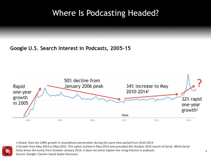
https://www.podomatic.com/login
=============
Multimedia Quizzes:
https://blog.stcloudstate.edu/ims/2016/02/13/4820/
==============
==============
==============
Save
Save
https://www.libraryjuiceacademy.com/moodle/login/index.php
Eva Dodsworth
Since the emergence of easily accessible dynamic online mapping tools, there has been a drastic increase in geographic interest and awareness. Whether for personal, social, professional or academic uses, people are using Geographic Information System (GIS) technology to communicate information in a map format. Whether it’s using Google Earth to study urban change, or creating Google Map Mashups to deliver library resources, more and more members of society are turning to mapping programs for their visualization needs. With so many using GIS technology in their daily lives, library staff are now more than ever assisting library clients with their mapping queries.
This course will introduce students to a variety of mapping tools and GIS technologies such Google Earth and the creation of dynamic KML files; ArcGIS Online and webmap publishing; Google Fusion Tables and geocoding; and GIS fundamentals with geospatial data creation. Students will be able to apply their GIS skills in their reference work, in digitization projects, in webpages, in library instruction, and more. Through hands-on exercises, pre-recorded demonstrations and lectures, students will receive a thorough overview of mapping resources that will enhance and expose their library’s resources.
http://www.lib.uwaterloo.ca/locations/umd/WeekOne_2014.wmv
http://www.placingliterature.com/map?modal=1
http://www.lib.uwaterloo.ca/locations/umd/WeekTwo.wmv
http://www.lib.uwaterloo.ca/locations/umd/WeekThree_Part_One.mov
http://www.lib.uwaterloo.ca/locations/umd/WeekThree_Part2.mov
http://www.lib.uwaterloo.ca/locations/umd/WeekFour.mov
– How to enable offline maps in your Google Maps app – http://www.huffingtonpost.com/map-happy/how-to-enable-offline-maps_b_6525832.html
– Huge news – Google Earth Pro, which used to cost the public $400 is now free! What does that mean for you? Extra features! You can import GIS files, tables, and export animated movie files! http://google-latlong.blogspot.com.es/2015/01/google-earth-pro-is-now-free.html
– Don’t live in Canada? Too bad! Google Maps plots best tobagonning hills in Canada!http://www.ctvnews.ca/canada/google-map-plots-canada-s-best-tobogganing-hills-1.2218207
– a map of 19 countries that were named after specific people – http://www.vox.com/2015/2/1/7954179/map-countries-pe
By Paul KerleyBBC News Magazine
http://www.bbc.com/news/magazine-30840318
Content for Week Two – February 9th – February 15th
Week Two:
Podcast includes:
- Citizen Mapping
- OpenStreetMap – crowdsourcing
more heads are better then one
NYPL geomapping volunteers.
http://www.openstreetmap.org/
citizen crime reporting app for NYPD http://www.nyc.gov/html/nypd/html/crime_mapping/nyc_crime_map_introduction.shtml
when the jet disappeared, crowdsourcing for parts on the satellite maps of the ocean
potholes map
maps of the threes. emerald bug in Mnpls
http://www.fuf.net/
how does foursquare and checkins in FB and Google +fit it
Podcast and Powerpoint can be accessed from:http://www.lib.uwaterloo.ca/locations/umd/JuicyLibrarianMaterial.html
Tutorials: Google Earth
Assignments:
1. Discussion question:
Discover some citizen mapping projects that you are interested in OR
Contribute your local knowledge to Google Map Maker AND Share with the class online
2. Google Earth Map
Please complete the tutorial and then create a map in Google Earth with the following components:
- A title
- A written introduction to your project
- At least five placemarks, embedded with html tags, and images, if possible.
- Imported KML file(s) file format by GEarth, but other apps is using it. using notepad or MS Word, one can create KML file.
screen overlay, can be text, image, anything. legend. HTML code.
- A screen overlay (i.e. a legend)
areal photography.
history.
images from the library, Google is willing to buy them. citizen mapping. scanning and uploading.
geographical and societal awareness.
Gallery: 360Cities.
google street view – historical views
Google Earth Mapping
Submit online as a KML/KMZ file
I had the opportunity to experience a gizmo that can be used to display a variety of mapping projects, including citizen mapping: Science on a Sphere. It is a sphere on which you can project static maps or animations. The one I saw, in the National Oceanic and Atmospheric Administration’s facility on Ford Island in Honolulu, displayed animations showing the 2004 Indian Ocean tsunami and the 2011 tsunami in Japan, as well as airline flight paths, ocean currents, polar ice cap change over time, and many other types of geospatial data.
The Great Backyard Bird Count actually starts today and runs through Monday, February 16th. At a minimum, it only requires 15 minutes of observation on any or all the days: http://gbbc.birdcount.org/
Happy Cow is a site well-known to many vegetarians/vegans for finding restaurants which I’ve used when travelling. Users can submit reviews and/or restaurants that they’d like profiled (although the site reserves the right to approve or not the listing). http://www.happycow.net/search.html
———————————–
One of the impediments to citizen mapping is the line-of-sight cell tower limitations of mobile phones, or the wifi requirements for other mobile devices. Citizen mapping in urban and suburban environments is well-served by mobile devices, but what about natural areas, dense leaf cover, or extreme topography? Even if obtaining absolute mapping coordinates isn’t the issue, much crowdsourcing assumes an ability to connect back to a central data repository (e.g., a web database, ‘the cloud’). Equipment that can interact with GPS satellites and support data capture is typically expensive and generally requires proprietary software.
wq (https://wq.io/) is a framework that is ‘device first’ and ‘offline-enabled’. It attempts to leverage several open source technologies to build an entire mobile solution that can support citizen science data collection work, and then synchronize with a central repository once the device (and operator) return to an area served by cellular or wifi networks.
I’m stretching here, so if I get stuff wrong, please don’t yell. Still, I’ll take a pass at generally describing the framework and its related technology stack.
wq relies upon python, and a web framework called django for building offline-capable web apps that can run on iOS and Android devices. These web apps, then, rely very heavily upon javascript, particularly requirejs (http://requirejs.org/) and mustache (https://mustache.github.io/), for the templates that permit quick and (somewhat) painless web application development. Data visualization relies upon d3.js (http://d3js.org/), and geography makes heavy use of Leaflet (http://leafletjs.com/) — maybe the most pertinent layer of the stack for those of us in this course. If you’re not familiar withLeaflet.js, check it out!
Finally, wq extends several other open source technologies to enable synchronizing between a central data repository and multiple mobile devices in the hands of citizen mappers. Lastly, wq employs a set of tools to more easily build and distribute customized mapping apps that can be served from Apple’s app store, Google Play, etc.
What wq intends is to allow highly specialized citizen science/citizen mapping apps to be more easily and quickly built, based upon a solid collection of aligned F/OSS tools. Ideally, an app can spin up quickly to respond to a particular need (e.g., a pipeline spill), or a specialized audience (the run up to a public comment period for a development project), or even something like a high school field trip or higher ed service learning project.
Some examples of citizen mapping projects already built upon wq are here:
https://wq.io/examples/
—————–
Creating a walking tour map with Google Earth_2014
————-
Week 3
Podcast includes:
- Geocoding
- Georeferencing
- Spatial Data Formats
- Geospatial Data Online
- Discussion Question
Podcast and Powerpoint available from: http://www.lib.uwaterloo.ca/locations/umd/JuicyLibrarianMaterial.html
Tutorials: BatchGeo (optional); Google Fusion (optional)
https://en.batchgeo.com/
enter Xcel data, and export KLM file ready for google map and/or google earth
https://support.google.com/fusiontables/answer/2571232
http://en.wikipedia.org/wiki/Google_Fusion_Tables
store maps online, no latitude needed.
visualize geospatial data by map
spatial analysis by mapping different layers together
showing data by map, graph or chart
e.g. how many cars cross specific point
crowdsourcing: spotting butterflies, using fusion tables to map the spices and sightings
http://www.theguardian.com/news/datablog/2011/mar/31/deprivation-map-indices-multiple
students: journalism, history, geography.
Georeferencing (geocoding – data, geo referencing – image)
historical air maps or photos are much more useful when they are georeferenced.
Photos from different year is difficult to lay over one another without referencing. the only reference might be the river. usually reference the four corners, but sometimes river. Using GIS program to determine the longitute/latitude for each corner. sometimes only farmland and it is impossible
How To Use The App That Will Make Your Photos Look So Much Better
http://www.businessinsider.com/how-to-use-vsco-cam-2015-1?op=1#ixzz3OeN3Fss0
VSCO Cam available for mobile devices
VSCO Cam allows users to transform bland photos into gallery-worthy artistic images.
The librarian 2.0: Identifying a typology of librarians’ social media literacy
http://lis.sagepub.com/content/early/2014/01/28/0961000613520027.full.pdf
Social media is the unifying term for these ‘new digital media phenomena […] in which ordinary users (i.e. not only media professionals) can com- municate with each other and create and share content with others online through their personal networked computers and digital mobile devices’ (Bechmann and Lomborg, 2013: 767).
First, social media communication is de-institutionalized, which means that media companies alone do not control the flow and distribution of information. Second, social media users are also information and content producers. We refer here to the collapse of production and consump- tion roles, labelled ‘prosumer’ (Jenkins, 2006) or ‘produs- age’ (Bruns, 2008). Third, social media communication is interactive and networked in nature.
public libraries must reconsider their positions as public knowledge providers (Anttiroiko and Savolainen, 2007). As a modern librarian’s task is to be able to use and distribute information in many formats other than print, he or she must be able to use all media, including digital media and social media.
social media literacy’ (SML), which is understood as ‘not only the practical and cognitive competencies pos- sessed by users of social media but also the motivation to employ these media effectively and appropriately for social interaction and communication on the web’ (Vanwynsberghe and Verdegem, 2013).
Zurkowski (1974: 6) defines ‘information literacy’ as the ability to utilize ‘the wide range of information tools as well as primary sources in modelling information solutions to their prob- lems’. With the rise of the Internet as a seemingly infinite source of information, the concept of information literacy gains more urgency (Sharpio and Hughes, 1996). In this respect, information literacy now includes having skills to identify an information problem (e.g. an unanswered ques- tion), accessing the location where information can be found, evaluating the information and using this informa- tion in problem-solving activities (Livingstone et al., 2005
The concept of information literacy was developed in the context of print media, while the concept of media literacy originated in the context of audio-visual media. media literacy was framed as the ability to critically under- stand media messages. Information literacy instead focuses on the basic competence of locating information since infor- mation is often difficult to find or use.
In con- trast to information literacy research, media literacy research has also paid attention to questions related to the creation of content (Livingstone et al., 2008).
The second cluster consists of respondents who have the lowest score for SML factors and consequently are labelled social media laggards. corresponds to people who have a rather negative attitude towards social media and do not (often) use social media at work or at home. Furthermore, social media laggards also have a very low level of social media knowledge and com- petencies. Of the respondents, 23.91% belong to this clus- ter; they have a high probability of being female and predominantly belong to older age groups.
The third cluster is the most social media literate group; therefore, we label respondents who fit within this cluster, social media literate users. Though its members are usually female, this social media literate cluster contains the most men in comparison to the other clusters. The members of this cluster are situated in the younger age groups. Hence, social media literates and social media workers include librarians who can serve as facili- tators or agents to guide and support other librarians dur- ing social media implementation.
four SML profiles: social media workers, social media laggards, social media literates and social media spare-time users. Social media workers are librarians who use social media mostly in the library and have a relatively high level of SML. Social media laggards do not use social media frequently either at home or at work and have a low level of SML. The social media literates are librarians who frequently use social media at home and at work and have a high level of SML. Finally, social media spare-time users are librarians who frequently use social media at home but not in the library and have an average level of SML.
http://www.cnet.com/news/how-do-you-make-a-good-virtual-reality-game-oculus-developers-gather-to-find-out/

Avoiding making people sick is one of the key struggles in producing VR games. Developers large and small have said games need to be made in new ways to protect players from motion sickness.